
Now a day it is very common thing and everyone knows that high intensity rainfall or cyclones can cause pluvial flooding in cities (Refer Image 1).

 Image 1: Pictures showing Pluvial flooding in Muscat, Oman due to Cyclone Gonu in 2007
To reduce the impact of these heavy rain events, traditional approached to rainwater management have involved channelling rainwater away from urban areas to Rivers or Sea by means of Sewers, drainage ditches or sometimes roads to convey the water. However with climate change, pluvial flooding events will be more frequent.
To address this big issue, relatively new approaches have developed. These are the urban design and water management approaches called “ Water sensitive Urban Design (WSUD) and Sustainable Drainage System (SuDS) ”.
These approaches have a number of key features that distinguish them from more traditional approaches to urban water management:
- Storing rainfall as close as possible to where it falls and releasing it slowly (attenuation) vs. removing it as quickly as possible;
- Allowing water to soak into the ground (infiltration) vs. transporting water over sealed surfaces into surface water bodies (artificial water channels); and
- Slowly transporting (conveying) the runoff vs. letting water flow quickly into sewer and drainage systems.
In addition, Water sensitive Urban Design (WSUD) and Sustainable Drainage System (SuDS) seek to exploit some additional benefits that include:
- Filtering out pollutants;
- Allowing sediments to settle by controlling the flow velocity of the water;
- Greening the city; and
- Mitigating the Urban Heat Island effect by providing more vegetation that cools the urban environment through evapotranspiration.
When comparing both, it must be pointed out that the WSUD represents a much wider and bigger framework. The Water sensitive Urban Design framework sees the city and its catchment and focuses on the management of the whole urban water cycle, including drinking water and wastewater. Furthermore, it is a more holistic framework as it integrates aspects from different areas of expertise including water management, urban design, landscape planning as well as ecology and social aspects.
Both Water Sensitive Urban Design and SuDS make use of vegetation (green) and water bodies (blue) infrastructures to manage huge rainfall. SuDS and WSUD do not comprise a single infrastructure but many infrastructures that are combined to form a “management train” that ensures appropriate management of urban water, prevents flooding and treats runoff/storm water. A selection of possible infrastructures is presented in the below given sub sections for Water Sensitive Urban Design.
1.1 Vegetated Swales


Vegetated swales can be used instead of pipes to transport runoff water and provide a ‘buffer’ between the area receiving water and areas allocated for infiltration. The vegetation in the swale also serves as the first treatment step to encourage settling of pollutants and uptake of nutrients by plants. In addition, swales can also have amenity value and provide habitats for wildlife. Refer Image 2 for pictures showing the vegetated swales in VHPP housing estate in Netherlands during Wet Weather and Dry Weather.
VHP Housing Estate may only be a small residential district in Netherlands but it exhibits a strong quality in its approach to nature. Refer image 3 for a schematic section of a dry swale. If properly designed and maintained, dry swales can provide storm water treatment while accenting the natural landscape.
1.2 Infiltration Trenches for Water Sensitive Urban Design
Infiltration trenches are shallow excavated trenches filled with crushed stone or gravels that looks aesthetically beautiful and are purely designed to filtrate the storm water though permeable soils into the groundwater aquifer. This is commonly used to treat runoff water from impermeable surfaces, such as parking lots, pedestrian pathways, on sites where there is limited or less space is available for managing storm water. Refer image 4 for pictures showing infiltration trenches along roads with beautiful landscaping.

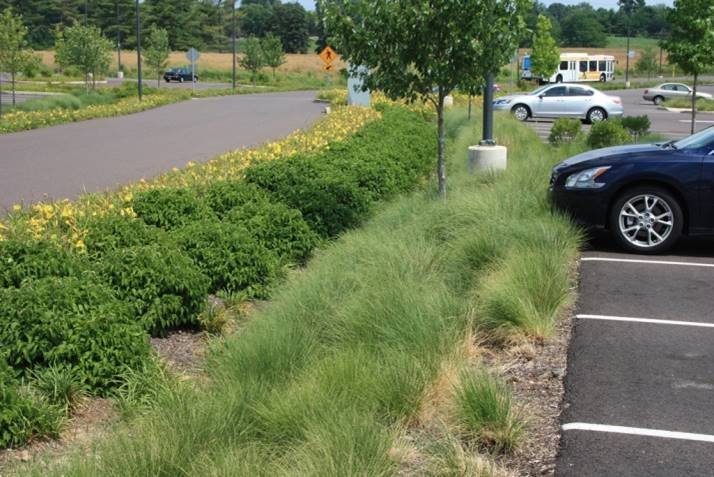
Image 4: Infiltration trenches along roads with beautiful landscaping

Infiltration trenches are easy to integrate into a site. They are best for use around playgrounds, parks, recreational areas, open sit out areas or public open space. They generally enlarge the soil moisture content and help to recharge groundwater, thereby reducing problems of low river flows. For its maintenance regular inspection are required for signs of clogging, removal of sediment from pre-treatment system and removal with cleaning or replacement of stone. If maintained well the infiltration can significantly reduce both runoff rates and volumes. Refer image 5 for schematic diagram of an Infiltration trench.
1.3 Retention and Detention Basin (Dry Ponds)
Retention basins are pond-like features with vegetation around their perimeters. They have a permanent pool of water and the water level is allowed to vary as a result of rain events. Water is released slowly from the retention basin into another body of water on the surface or partially infiltrates into groundwater. Contrary to retention basins, detention basins are not permanently wet; they are sometimes called “dry ponds”. Both detention and retention ponds delay runoff and contribute to the treatment of storm water through different passive treatment processes such as filtration, sedimentation, absorption and biological processes. Refer image 6 for pictures showing retention and detention basin during dry weather and wet weather. During dry weather the same area can be utilized for various purposes like playground, gathering spot, open air theater etc.
Image 6: Retention and Detention basins during Dry weather and Wet weather


Retention ponds are open areas of shallow water mainly designed so they can accommodate rain water and provides temporary depository for excess storm water. In this technique the water level rises temporarily when it rains, but there is always availability of permanent pool of water. They are quite similar to wetlands, but they are more useful than wetlands for storing excess storm water. The design of retention ponds permanently storing water is what differentiates from detention basins. Refer image 7 for a schematic diagram showing section of retention and detention basin.
1.4 Rain Gardens
A rain garden is generally a garden of local shrubs, perennials and various flowers planted in a small depression area, which is generally formed on a natural slope (sometimes created slope). It is mainly designed to temporarily keep and finally soak in rain water that flows from various habitable areas or along roads. The vegetation that grows in the filter media enhances its function by:
- Preventing erosion of the filter medium;
- Taking up nutrients and water;
- Continuously breaking up the media through root growth to prevent clogging of the system; and
- Providing bio-films on plant roots into which pollutants can adsorb.
In rain gardens, storm water runoff is filtered through a vegetated sand media layer. It is then collected through perforated pipes so it can flow to downstream waterways or into other features such as retention or detention ponds. Refer image 8 for pictures showing rain gardens.
 Image 8: Pictures showing beautifully landscaped rain gardens

If a rain garden is designed correctly and the site is prepared well, maintenance is not much different than the typical maintenance for a landscaped garden. Refer image 9 for the typical schematic diagram of a Rain garden.
1.5 Constructed Wetlands
Constructed wetlands are man-made vegetated structures that are partially saturated with water, either permanently or temporally. They mimic the treatment processes that are taking place in natural wetlands. Constructed wetlands can be similar to a pond, where water flows horizontally over the soil, or comparable to a rain garden. The water is treated through physical (sedimentation, filtration), biological (microbial activity and uptake by plants) and chemical (adsorption, UV degradation) processes. Wetlands can also provide habitat for wildlife and a focus for recreation, such as walking paths and resting areas. Refer image 10 for pictures showing beautifully landscaped constructed wetlands serving as local recreational areas.

 Image 10: Pictures showing constructed wet lands serving as recreational areas

The constructed wetlands are designed like self-sustaining wetlands. Their lifetime costs are much lower than other treatment systems; often their capital and maintenance costs are also lower compared to other treatment systems. Refer image 11 for schematic sectional diagram of a constructed wetland.
To further explore water sensitive urban design (WSUD), the manuals which are in practise and following in Singapore and Melbourne are one of the best in the world for Water Sensitive Urban Design (WSUD) and Sustainable Drainage System (SuDS).